Enkin's Rafael Spring and Max Braun created a new 3d-navigation system for Android phones that even includes a "radar" map of POIs (Points of Interest) that changes orientation as you change the orientation of the Google Android mobile device. Rafael and Max both study Computational Visualistics in Koblenz, Germany and started this (private) project when they were in Osaka, Japan for Robotics Research.
They told me, "We are both really excited about it since there is nothing even similar on the market, yet. Our project, which is called "Enkin", uses different kinds of sensors, live camera views, GPS, wireless internet and a lot of new interfaces provided by the Android platform to introduce a new way of navigation."
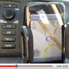
Enkin allows you to navigate through your environment without using a map. Instead, all your navigational content (such as directions, annotated placemarks, etc.) is displayed extending real objects on the screen, using the devices built-in camera. Turning and moving the device will make the camera image and the content float by.
Enkin uses GPS to determine the user's position on the globe and motion-sensors to calculate the device's current orientation in space. So when you aim your camera at say Yankee Stadium from 100m away, the phone's video display will overlay the "real world" image of Yankee Stadium with annotated text that says "Yankee Stadium 100m". Even cooler, say you are lost in the Bronx and are trying to find Yankee Stadium -- simply swivel your camera around until you see the annotated text "Yankee Stadium 100m" on the screen. Even if the Stadium is blocks away behind several buildings, since it uses GPS and motion sensors to detect your orientation, it doesn't require line of sight.
Another perspective in Enkin makes you watch your content from a virtual camera high above you. The content then comes embedded in a fully textured three-dimensional landscape.
According to Enkin, tou can also see your content on a classic 2D map (driven by a motionsensor-interface) which is similar to Google Maps. The different views can be switched seamlessly using 3D graphics. You can therefore "dive" right into a map. Enkin combines GPS, different orientation sensors, 3D graphics, live video and several web services into an exclusively mobile application.
Enkin will be released soon after the first Android devices are available.
Sometimes seeing is better than explaining. So check out the cool video!